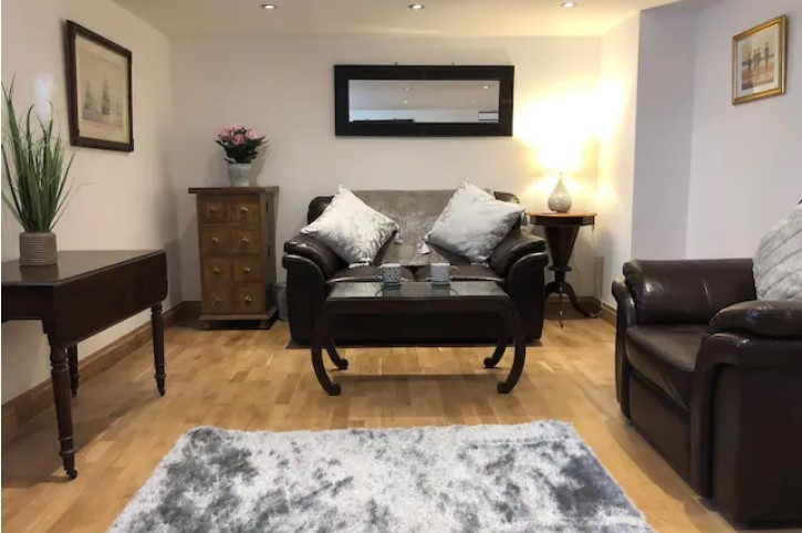
Haydock Place
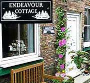
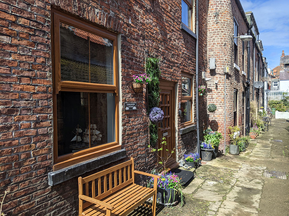
Endeavour Cottage in Whitby located in the courtyard of Haydock Place.

Endeavour Cottage Sleeps 6.
Characterful old Whitby Yard only couple of minutes stroll to harbour. Quiet cul de sac location.
Sea View Cottage Sleeps 4. End of Pier Road with unrivalled views of the sea from all rooms. Quiet location.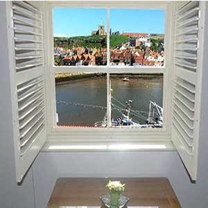
Whitby Harbour Apartment Sleeps 5. Views over towards Whitby Abbey and out to sea from lounge and master bedroom. 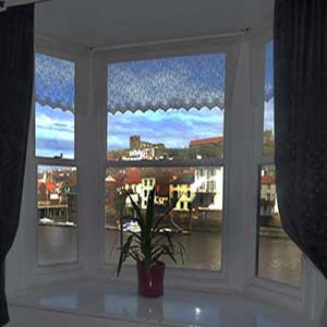
Whitby Retreat Sleeps up to 10.
Whitby Retreat Aparments face whitby and the North Yorkshire Moors with a private gravel garden with apple trees.
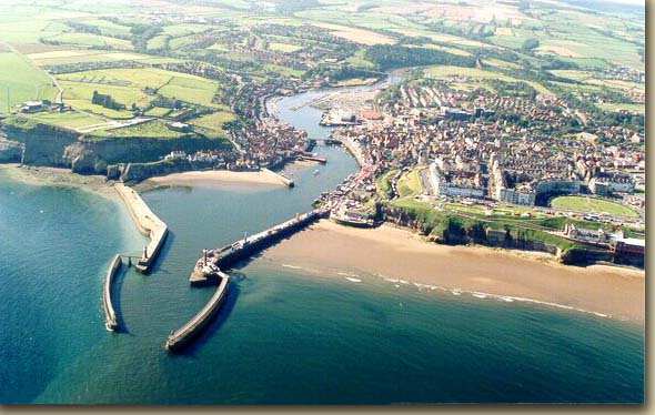
Whitby is an old fishing port on the East coast of the UK, divided by the River Esk which heads out to sea. Location it is approximately midway between Humber and Tyne. Its greatness is mainly due to the fact that the old properties and fishermen’s cottages are built as close to possible to the sea, obviously because this made the work easier for the fishermen.
The town still as traces of ancient Britons, with place names in the vicinity remain as evidence. Earthwork remains exist which are known as the Killing Pits, which is an area very dense with circular cavities-near Goathland and in other parts of the district, and other remains go to prove that the place existed in the time of the Druids. These are the remains of old villages from times gone by and on the moors the tamales are provided remains of dead inhabitants which date from the pre-Roman times. There has also been flints which also provide a story of the age of people who lived in this area.
Regarding the Roman occupation there is still plenty of evidence to support their existence in this area including various camps, with a Roman road still traceable from York to Dunsley Bay. Officials there are no recorded records that a Roman station existed there. Bede, who wrote two hundred years after the departure of the Romans, interprets Streonshalh, the name of the bay at the time, as “Sinus Fari”-the Bay of the Lighthouse.
There is never actually been any Roman antiques found in the town itself although they have been found within a few miles of the centre.
Tweet - FB Like Us or G + Us..
The Danes destroyed the monastery and the town of Streonshalh in 867, and both lay desolate for two hundred years, and in fact it was the Danes
Who were to become the next invaders to descend upon Britain and the Kingdoms of East Anglia and North Umbria. They totally engulfed the whole coastline of Yorkshire .
It is indeed this part of Yorkshire which became the habitation of these invaders, which means that even today there are ancient language still survives in provincial words and place-names than in any other neighbourhood.
There were many changes later when the Norman conquest occurred and in William’s distribution of territory to his followers, Whitby and its dependencies and the manors of Hinderwell and Lofthouse were conferred on the Conqueror’s nephew, Hugh de Abrincis, Earl of Chester, under whom William de Percy held Whitby Abbey and the lands belonging to it.
The Percys were the chief benefactors on the re-establishment of the monastery, which took place in 1074, Whitby, like its predecessor Streonshalh, rose as a dependency of the Abbey, The name has been said to mean White village, from the aspect of the new erections; which brought about the name of Priestby, which means priest's village during the period of the conquest.
The Doomsday book provides evidence that place names of the district in 1840 and the names including Whitby, Stakesby, and Newholm , including the manner of Lofthouse, with the lands of Hinderwell, Boulby , Eastington , Guisborough and other areas. Most of the areas surrounding Whitby are mentioned in the Doomsday book, with some of these names disappearing over time. The facts are that the majority of the names of the villages surrounding Whitby is over 900 years old.
The Abbey became prominent and grew in size and wealth, and this caused the town to also increase size spreading out along the river Esk. In a location where Church Street now exists, and also as a port of Whitby,, the town was granted to the monks by William de Persy and the fishermen also became prominent during the same period in time, inhabiting soon after the conquest.
The majority of the town was situated underneath the cliff, with the majority of people building their houses along the banks of the River, with the higher section being chiefly occupied by officers and their liberality.
Peter was the succeeding Abbot, taking possession of the monastery and buildings, and so before the period of 1189 Whitby itself and developed into quite a considerable community, so much so that the Abbot Richard de Waterville granted his charter, so allo wing it to be become a free borough, with similar privileges to other boroughs.
The inhabitants of the town experienced a limited period of liberties, because the monks were jealous of their rights, and repented of King John for a repeal of the charter. The son of the Ludof William Clerk, Ralph and also Simon de Keseburn are on record as being the restricted the withdrawal of Whitby’s rights.
Some of the most important streets in Whitby go back to a very ancient date, like Flowegate which obtained its name from any charter dated 1222 to 1224, which was the period when the Abbot was Roger, with other witnesses being William, who was a merchant.
Haggersgate , which was referred to at the time as Hacllesougate was named approximately 1296, followed by Kirkgate or Church Street in 1318.
Grape Lane and developed with houses on either side of the street at 1595 and Bridge Street, along with Sandgate are of a similar age If not older. There was a house that was the situated very close to the bridge, which had title deeds in the name of John Carlill, and his form of occupation was as a jet worker.
In 1595 Bagdale Hall and a few other dwellings nearby are mentioned with the term “nere unto Whitbie” but actually the street of Bagdale has no mention at all.
During this period there were houses along Skate Lane, which is now ca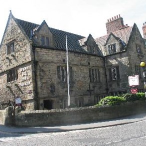 lled Brunswick Street, but the streets during this period in time were just mud tracks with thatched cottages, built detached.
Picture on the right of Bagdale Hall as it now looks.
When the dissolution of the monastery occurred in 1540, a large section of Whitby became the possession of Henry V111, which later became passed on to the Cholmley family. Interestingly, it is recorded that 400 houses, 300 messuages, 100 cottages, 200 gardens, 2 water-mill, a windmill, 10,000 acres of land, 1000 acres of Meadow, and 10,000 acres of pasture were purchased by Sir Richard Cholmley. This took in the areas, such as Whitby, Larpool, Stainacre, Hawsker, Fyling, Stakesby, Wragby, Spring Hill, Sneaton and Daleshead.
Follow Us Please.
Endeavour Cottage in Whitby located in the courtyard of Haydock Place.
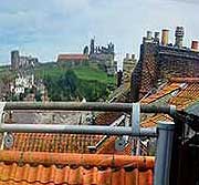
Across the rooftops of Whitby towards the abbey
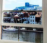
A view of Whitby Abbey from a cottage window.

We could provide high occupancy.
Want more booking for your holiday accommodation?
List your property with us. no contract red tape, no setup fee. Just bookings if and when you want them.
Whitby Holiday Cottages Letting Agency.